Article
Together with Dr Eng. Tadeusz Szczutko, professor at the AGH University from the Faculty of Geo-Data Science, Geodesy, and Environmental Engineering, we discover what is the designation of the blue poles that cyclists riding from Krakow to Tyniec ask about.
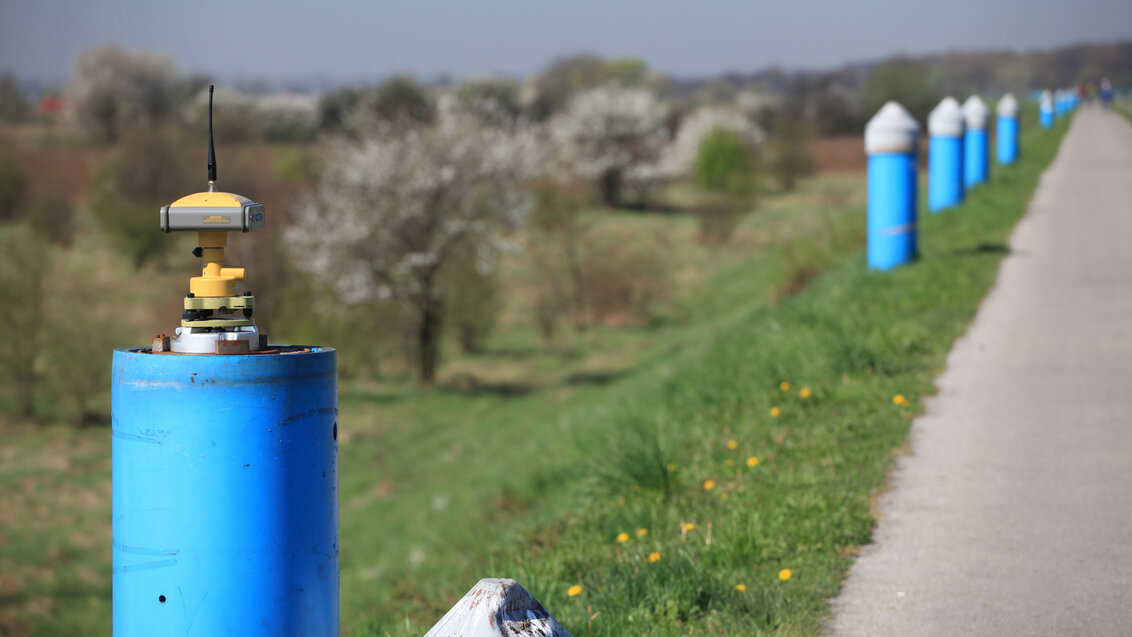
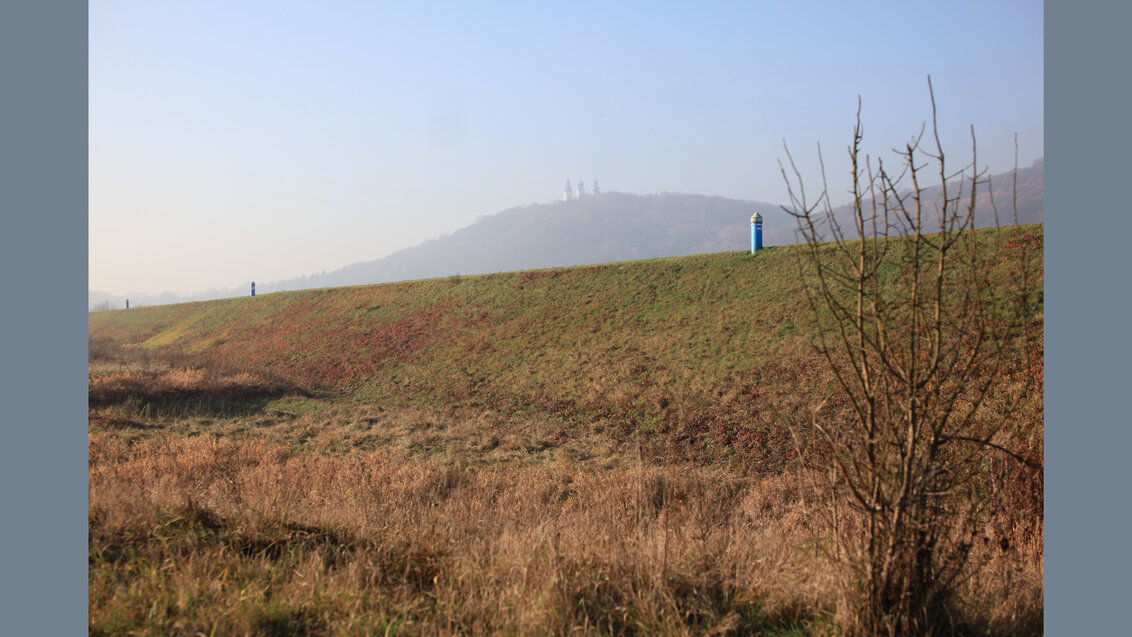
These characteristic installations are situated in the crown of the Vistula River embankment, at the height of a former village Bodzów, about 6 km up the river from the city centre. Cyclist riding the bike lane on the embankment towards the Benedictine Abbey in Tyniec can see them over their left shoulder, on the riverward side of the mound.
Dr Eng. Tadeusz Szczutko, professor at the AGH University; photo from professor’s archives
Professor Tadeusz Szczutko is connected to this place like no one else. He takes care of the infrastructure located here, in the creation of which he had participated three decades ago. The works conducted here were also the subject of his doctoral thesis. Whenever he is in the field, he frequently has to face the interest of cyclists passing the lane. Those interested enquire about what the installations neighbouring the asphalt tract are used for.
“I ask them in return to choose one of three options based on their own knowledge: 1. This is a set of sensors for checking the stability of the embankment; 2. These are just empty pipes that, in case of the city flood hazard, can be filled with dynamite so that the embankment could collapse and the water could spill before reaching the city; 3. This is a field length measurement device used for testing geodesy equipment,” responds jokingly.
Those seeking answers most often choose option number one. Some fall for the second variant, which refers to a city legend heard by the professor from one of the persons who talked to him at the embankment. The last response is selected by few. We would like to emphasise that this is the only correct answer. The poles do not hide any sensors. They also are not some part of military plans for the protection of Krakow from the high water. They are used by geodesists, specifically in geodetic meteorology.
Field length measurement
The field measuring points constitute the “Wisła” testing baseline. It is part of the Geodesy Metrology Lab which belongs to the Faculty of Geo-Data Science, Geodesy, and Environmental Engineering. Lengths between the poles create a measurement which is a reference for verifying the correct operation of measuring instruments used by geodesists.
A total station at one of the measuring points; photo by Tadeusz Szczutko
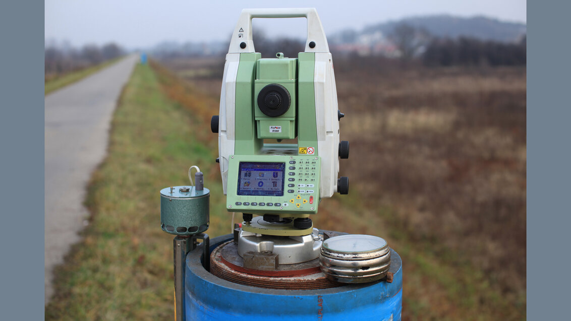
It is here that we can observe, among others, how electro-optical rangefinders determine distances.
“This is about the requirements resulting from abiding regulations. For example, while measuring geodetic control networks, the equipment should be tested and proven and have adequate corrections set. We are talking here about an accuracy of tenths of a millimetre. The best possible weather for measurements is about +15 °C, constant atmospheric pressure, and cloudiness. It is then that the results are not compromised by air vibrations”, describes Professor Tadeusz Szczutko.
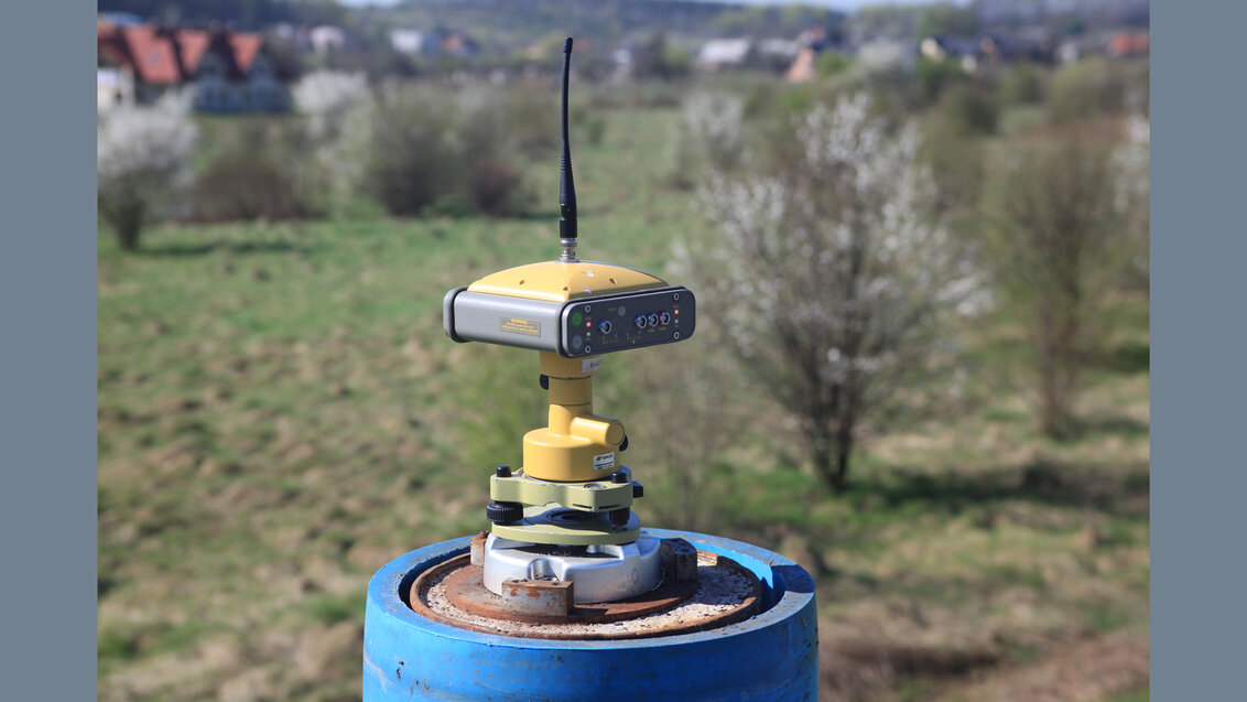
The infrastructure also enables testing specialistic GNSS receivers (Global Navigation Satellite Systems). For this purpose, they are mounted on tribachs placed on the poles.
“For now, we lack strict requirements in the matter and there is no obligation to test each purchased receiver. In spite of that, during their field works, geodesists should use them in a controlled way. If a singular device allows to pinpoint a position to the nearest 3 cm, the person performing the measurements should verify its accuracy by measuring a few points, the coordinates of which are already known,” explains the AGH University geodesist.
It all began at Błonia Park
The beginnings of the “Wisła” testing baseline reach as far back as 1981, when first installations appeared in the present location. Prior to this, the AGH University had had a base consisting of points in the ground of Krakow’s Błonia Park.
“The points were covered in turf. You had to know where to look for them”, reminisces those installations Professor Tadeusz Szczutko.
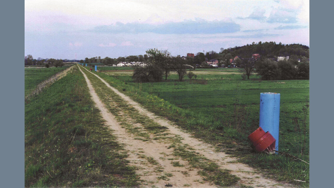
The new baseline in Bodzów operated from 1982 to 1995. It was brought to a halt and its infrastructure was dismantled due to works related to modernisation and waterproofing and sealing of the embankment. In 1997, the base was rebuild in its current form.
“Wisła” baseline before laying the asphalt surface on the embankment crown; photo by Tadeusz Szczutko
The keeper of the baseline focuses on the fact that this is a model location as regards the reliability of performed measurements:
“Firstly, we have here a rectilinear, flat stretch which would be hard to find anywhere else. Secondly, there are no external sources of interference in this location, which is particularly relevant during GPS measurements.”
Six metres above ground
The entire infrastructure consists of 20 poles which stretch for 1230 metres. Looking from the eastern end of the base, the first 4 poles were placed in the distance of 26, 39, 52, and 78 metres from the pole being the base’s starting point. The distance between the next ones amounts to 77.5 m. The last pole is the only exception as it is located only 64 m away from the preceding pole. What stabilises the structure are steel pipes which are 6 metres long with a diameter of 30 cm, concreted in 6 metres deep bores drilled in the embankment. Pipe ends protrude 1.5 m above the ground level and are covered with thermal shield made out of a water supply pipe which is 1.8 m long and has a diameter of 40 cm.
“Wisła” testing baseline today; photo by Tadeusz Szczutko
“As regards the stabilisation of geodetic points and the prevention of their movements, first of all, it has to reach lower than the freezing point of the ground, which in this case is 1 metre. Secondly, if a point is mounted below the freezing point, it is susceptible to movements resulting from silt swelling. Depending on the water level, the silt moves. In the case of rivers, the moisture level is higher than the water table, that is why specialistic stabilisation is needed. Meanwhile, as far as the thermal isolation is concerned, it is important for the steel not to heat up under the influence of sunlight,” claims the baseline keeper.
Sun rays falling on the pole from one side can lead to its deflation. Such deviations from the deflection norm which are measurable and can interfere with measurement results amount to tenths of a millimetre. Therefore, the poles should be adequately protected.
Unauthorised use
Besides some cases of scrawls on the poles, the elements of the testing base were not subject to serious acts of vandalism. However, one of medical companies, without asking for permission, put its posters on the poles. Then, an authority responsible for the supervision of the embankment reacted accordingly.
The geodesist from the AGH University responds:
“They truly dislike when any economic activity is conducted within their authority. They also suspected that we took some money for those advertisements. Before, these posters did not bother me that much because it all looked quite homogeneously and did not catch the eye. When someone sprayed some nonsense, the adds covered it. After the intervention, an employee of the council took them down, but soon after they were there again. So I asked our legal advisers to write the company a direct letter with a call to immediately put an end to such an activity. As a result, advertisements have never appeared again.”
In addition to the unpleasant occurrence, the baseline was used not necessarily as intended other times in the past. But, it was for quite different and useful reasons.
“Some time ago, as part of a science fair, I organised an event under the slogan ‘check your bike’. I designated a section of 1010 metres, so that everyone could check whether their bike computers measure the covered distance correctly. Other time, we tested a professional odometer which was used for locating places on a motorway where some damage on the surface occurred. It was a device placed on a wheel, they drove back and forth, and we set it according to our directions,” reminisces the scientist.
GPS supports rangefinders
The character of works conducted in the baseline has changed over the years. GPS receivers are replacing the formerly used rangefinders.
“We currently study a few units a year, it used to be a dozen. At present, the companies which carry out geodetic measurements take advantage of GPS receivers which have become relatively cheaper. Nowadays, rangefinders are only used in rough terrain, for example in the mountains where the GPS signal is distorted or in the mines,” describes Professor Tadeusz Szczutko.
A GNSS receiver at one of the measuring points; photo by Tadeusz Szczutko
The AGH University scientist underlines that even though the measurements performed at the baseline have a utilitarian goal, they also serve science:
“Our research and publications created in the process have been frequently based on research commissioned privately. Owing to that, it is a real material, not some fabricated concept. We can for example differentiate between certain characteristics of GPS receivers and antennas used in them by using their various types to obtain measurements. In daily geodetic practice, it does not have a deep meaning, but it may be truly interesting in scientific terms.”
Part of the research results and their interpretation can be found in a book Realizacja polowego wzorca długości z wykorzystaniem pomiarów GNSS na przykładzie bazy „Wisła” by Tadeusz Szczutko which was published in 2018 by AGH University Press.
 Join the “My 2 Minutes” training. Build your career path in Poland at AGH University
  AGH Solar Plane develops fast and agile Rico plane
  Twelve universities and Krakow Municipality join forces for accessibility
  Leading AI researchers to meet at AGH University
  AGH University and the National Museum in Krakow to cooperate in the field of AI
  AGH University at European Economic Congress
  Become an analog astronaut: call for applications for NAWA UNIVERSEH OPEN